l’acqua che bevo

mapping drinking water access points in the Umbria region

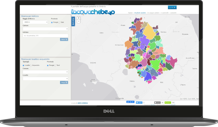
The portal offers the possibility of checking the drinking water access points throughout the Umbria region on a map. From the nearest monitoring points, you can find out the results of water analyses, learn more about the meaning and ideal values of each parameter, and find out the annual trend in chemical characteristics, discovering whether the permitted limits have been exceeded at certain times.

By means of simple and intuitive clicks, you can access the most recent measures issued and get an overview of the bodies that control and monitor the water we drink to find out more about the waterworks system in the region.

Arpa Umbria is the first environmental agency in Italy to provide users with an application that allows them to consult all the information on drinking water in Umbria on their smartphones.
Caso di successo - L'acqua che bevo

promotion of the environmental theme

The project, promoted by the Umbria Region and carried out by the Regional Agency for Environmental Protection in cooperation with the Umbrian Health Authorities and Water Service Managers, aims to promote greater awareness of the quality of the water that flows from our taps.

The aim is to provide a comprehensive knowledge of the water distribution, control and monitoring system in order to raise the awareness of inhabitants on the environmental issue of drinking water.

Innovative character of the application

  • Water health information

The aim is to stimulate knowledge of the network system of aqueducts in our cities, to learn about water parameters and the system of bodies working to make the system functional.

  • Tap water

The project aims to provide accurate and timely information to make people aware of their choice to drink tap water. What better strategy to promote the habit of drinking tap water than information on its quality?

  • Knowledge of the aqueduct network system

Last but not least, for those who enjoy walking or cycling in the city and beyond, it is useful to know the location of public drinking fountains!

Project realised for Arpa Umbria

Arpa Umbria is a public body dealing with environmental prevention and protection. The Agency’s mission is to provide technical and scientific support to the Region and other local authorities in the field of pollution prevention and environmental protection.

The Agency’s activities cover numerous topics including air, water, electromagnetism, noise, soil, waste, biodiversity, radioactivity, training, information and environmental education.

Contribution to sustainable urban development

The project aims to contribute to the achievement of the following Sustainable Development Goals of the 2030 Agenda, defined and promoted by the United Nations:

sdg6

SDG 6. Clean water and sanitation

Access to drinking water and sanitation is a human right and, together with water resources, a determining factor in all aspects of social, economic and environmental development.

By mapping drinking water access points throughout the Umbria region, the aim is to ensure universal and equitable access to drinking water, making it available and affordable to all. By monitoring the chemical characteristics of water, it contributes to improving water quality, reducing pollution and communicating to citizens the importance of integrated water resource management at all levels.

It contributes to the following sub-goals:

6.1: By 2030, ensure universal and equitable access to clean and affordable water for all
6.3: By 2030, improve water quality to reduce pollution by minimizing the release of chemicals and hazardous materials, halve the proportion of untreated wastewater, and substantially increase recycling and safe reuse globally
6.5: By 2030, implement integrated water resources management at all levels, including through transboundary cooperation as appropriate.

sdg11

SDG 11. Making cities and human settlements inclusive, safe, durable and sustainable

Global urbanization is one of the most significant developments of the 21st century. More than half of the world’s population lives in cities, a percentage that is expected to increase to 70% by 2050. It is cities that drive local and national economies, as centers of prosperity where more than 80% of global economic activity is concentrated.
New technologies make it possible to build a network to monitor mobility and people flows, to ensure safe and integrated coordination of cities during times of conviviality and cohesion. The benefits are numerous: they affect the economic apparatus of the territory, helping to provide access to safe, accessible transport systems; they achieve integrated and sustainable urbanization, providing universal access to safe public spaces; they enhance understanding of cultural heritage.

CONTRIBUTES TO THE FOLLOWING SUB-GOALS:

11.2: By 2030, provide access to safe, accessible, and sustainable transport systems for all, improve road safety, in particular by expanding public transport, with particular attention to the needs of those in vulnerable situations, women, children, persons with disabilities and the elderly
11.3: By 2030, improve inclusive and sustainable urbanization and capacity for participatory, integrated and sustainable human settlement planning and management in all countries
11.7: By 2030, provide universal access to safe, inclusive and accessible green and public spaces, particularly for women and children, older people and people with disabilities
11.4: Strengthen efforts to protect and safeguard the world’s cultural and natural heritage

sdg13

SDG 13. Promote action, at all levels, to combat climate change

Climate change is a key challenge for sustainable development. Global warming is causing changes in the global climate system that threaten the survival of large segments of the population in less developed countries, while infrastructure and some economic sectors are vulnerable to the risks of climate change, particularly in developed regions.

Smart and coordinated city management enables the public sector to facilitate widespread environmental awareness and education, building institutional capacity over time for sustainable climate change mitigation, impact reduction, early warning and efficient response strategies and planning.

CONTRIBUTES TO THE FOLLOWING SUB-OBJECTIVES

13.1: strengthen resilience and adaptive capacity to climate-related risks and natural disasters in all countries
13.2: integrate climate change measures into national policies, strategies and planning
13.3: improve education, awareness and institutional capacity on climate change mitigation, adaptation, impact reduction and early warning

sdg15

SDG 16. Protect, restore and foster sustainable use of the Earth’s ecosystem

It contributes to the following sub-goals:

15.1: By 2020, ensure the conservation, restoration and sustainable use of inland freshwater and terrestrial ecosystems and their services, in particular forests, wetlands, mountains and drylands, in line with obligations under international agreements
15.3: By 2030, ensure the fight against desertification, the restoration of degraded land and soil, including land affected by desertification, drought and flooding
15.5: take urgent and significant action to reduce the degradation of natural habitats, halt biodiversity loss and, by 2020, protect and prevent the extinction of threatened species
15.9: By 2020, integrate ecosystem and biodiversity values into national and local planning, development processes, poverty reduction strategies and guidelines.

Find out more about the product used

decision support system icon

Decision-making
support

Geoanalytics is a decision support system (DSS) based on city data.